Dubai Way: The Road That Reads the City Like a Map
Dubai Way — D89 — is not the longest road in the city, nor the most famous. But drive it end to end and you will pass through more of Dubai’s true character than any single highway has a right to show you. From old creek neighbourhoods to tower districts to desert-edge suburbs, it is a cross-section of everything the city became.
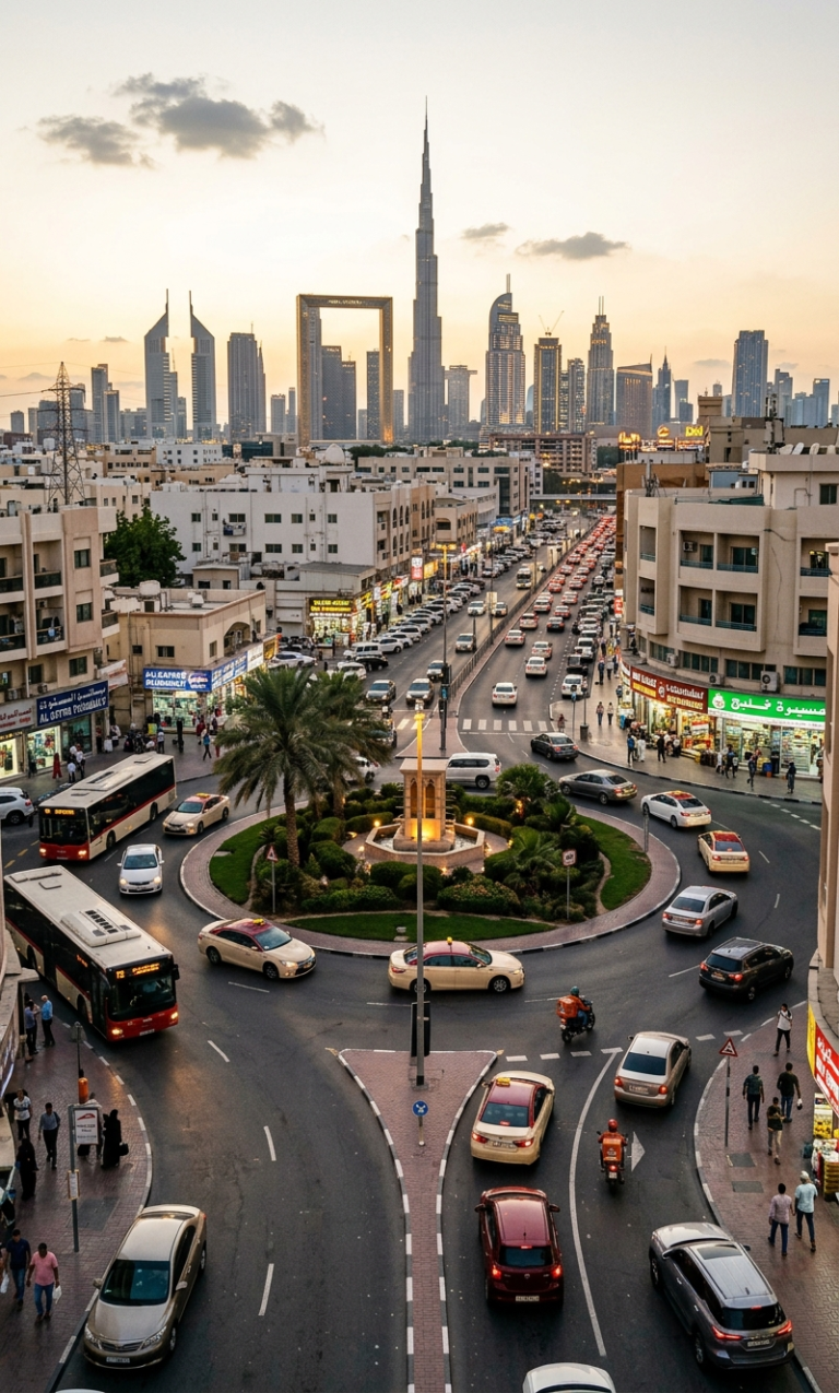
Illustrated streetscape along Dubai Way (D89) — the multi-lane highway that traces the city’s urban evolution from creek to desert edge · Dubai Daily Press
Every city has a road that tells its story better than any guidebook could. In London it is the A4 — from the City out through Hammersmith and into the west. In Los Angeles it is Sunset Boulevard, which begins downtown and finishes at the Pacific. In Dubai, that road is Dubai Way.
Designated D89 on official road maps, Dubai Way is a dual carriageway that cuts broadly east to west across the city, threading through layers of development that span six decades. Where Sheikh Zayed Road runs parallel to the coast with its famous procession of towers, Dubai Way runs slightly inland, through the neighbourhoods that existed before the skyline. Drive it in full and you will pass through stretches of Dubai that tourists rarely see, that residents hurry through without looking, and that explain — more honestly than any glossy map — how the city actually grew.
“Dubai Way is the city’s spine, and the city grew the way spines do — in layers, one vertebra at a time, each decade adding something new without quite forgetting what came before.”
Dubai Daily Press · June 2026Where It Begins: The Creek End
At its eastern terminus, Dubai Way originates near the old districts that bracket the Dubai Creek — Deira to the north, Bur Dubai to the south. This end of the road is the oldest in feel. The buildings are lower, the signage is in Arabic and Hindi and Tagalog simultaneously, and the streets feeding off the main carriageway narrow quickly into the kind of lanes that were never designed for modern traffic volumes.
The Meena Bazaar area, which the road skirts at its eastern approach, is one of Dubai’s great surviving wholesale markets. Textile merchants have occupied the same premises here for fifty years or more, their shop fronts stacked floor to ceiling with bolts of fabric that catch the light in the afternoons. The road here smells different to the rest of the city — cardamom from the spice traders, diesel from the delivery trucks, the particular salt-and-rust smell of old creek-side infrastructure.
- Official code D89
- Runs East–West across central Dubai
- East end Near Bur Dubai / Meena Bazaar
- West end Merges toward Al Quoz / Interchange areas
- Key districts Bur Dubai · Karama · Satwa · Sheikh Zayed Rd corridor · Al Quoz
- Metro access Multiple Red Line stations within walking range
- Best driven Early morning or after 9 pm to avoid peak congestion
Through Karama: The City at Its Most Human Scale
The section of Dubai Way that passes through and beside the Karama district represents, for many longtime residents, the road at its most characterful. Karama is a low-rise residential and commercial area that has remained largely unchanged in its basic footprint since the 1970s, even as the city immediately to its west transformed beyond recognition.
The covered Karama Shopping Complex sits just off the road — a complex of small shops selling everything from electronics to sports shoes to handmade handicrafts. Its covered walkways are busy at all hours, and the cluster of restaurants on its southern side offers some of the most concentrated affordable dining in a city that has become expensive for daily life. Indian and Pakistani lunch spots, Filipino fast food, Egyptian koshari restaurants — the concentration of cuisines here reflects Karama’s position as one of Dubai’s most important residential areas for working-class and middle-income expatriates.
Karama was developed in the early 1970s as government-built housing for Dubai’s growing expatriate workforce. Many of the original apartment blocks are still in use today, making it one of the few areas of the city where the original urban fabric survives more or less intact. The neighbourhood is named after the Karama Housing Complex, the first large-scale residential project built by the Dubai Municipality.
Dubai Way at night — headlights and tail-lights trace the carriageway as the city’s traffic continues past midnight, as it always does · Dubai Daily Press
The Satwa Section: Where the Road Gets Interesting
As Dubai Way passes through or near the Al Satwa neighbourhood, it enters the section of the journey that most rewards attention. Satwa’s famous roundabout — the neighbourhood’s gravitational centre — sits just off the main road, and the streets feeding toward it from the highway are dense with the kind of urban texture that is increasingly rare in the wider city.
The tailoring district here spills close to the road: small shop fronts with fabric samples hung in windows, hand-lettered signage offering alterations and bespoke commissions, men sitting in doorways in the late afternoon heat. The food stalls and restaurants that define Satwa’s character are more visible from this stretch than from any other approach, and the evening foot traffic between the road and the roundabout gives this section a particular energy during the hours between sunset and midnight.
If you are approaching Satwa Roundabout from Dubai Way by car, the most useful turn is onto 2nd December Street heading north — it brings you directly into the heart of the neighbourhood and has more parking options than the roundabout approaches. The walk from the road to the main shawarma strip takes under five minutes.
On weekday evenings, the traffic on Dubai Way at this section moves reasonably freely. On Fridays between 8 pm and midnight, expect significant slowdowns as the area draws visitors from across the city.
The Sheikh Zayed Road Crossing
One of the road’s most dramatic moments is its intersection with Sheikh Zayed Road — the E11, Dubai’s most famous highway, which runs parallel to the coast and carries the bulk of the city’s through traffic. The crossing is an interchange of some engineering ambition, with overpasses and slip roads creating a multi-level exchange between the two arteries.
From the elevated section at this crossing, the view is one of the better free panoramas of central Dubai. To the north, the towers of the Trade Centre and Business Bay clusters rise in a broken procession. To the south, the road descends toward the older districts. For a few seconds at the top of the flyover, the city presents itself as a single composition — which it rarely does from ground level, where its scale and its complexity tend to overwhelm any attempt at overview.
Dubai Way (D89) is classified as a District Road in the Dubai Roads and Transport Authority’s hierarchy, meaning it functions as a secondary arterial route connecting neighbourhoods rather than as an inter-emirate or primary expressway. Despite this classification, it carries significant volumes of daily traffic because it provides east-west connectivity that the major E-roads do not offer in the central city areas.
Al Quoz: The Creative and Industrial West End
As Dubai Way approaches its western extent, it passes through or near Al Quoz — a district that is one of the city’s most instructive contradictions. Al Quoz is primarily an industrial area, home to warehouses, auto workshops, building material merchants, and light manufacturing facilities. It is also, improbably, the city’s most significant arts district.
The galleries, studios, and creative businesses that have colonised Al Quoz’s industrial units over the past decade represent the side of Dubai that receives the least international attention but that residents consider genuinely significant. Alserkal Avenue, the cultural campus at the heart of the district, houses over sixty creative enterprises in converted warehouse spaces, ranging from contemporary art galleries to architecture studios to independent cinema. The road passes close enough to this cluster that its exit, on weekend evenings, is unmistakable — cars parked at odd angles, people walking with that particular gallery-district purposefulness.
“In Al Quoz, warehouses became galleries and loading docks became terraces. Nobody planned it. It happened the way good things happen in cities — sideways, gradually, and then all at once.”
Dubai Daily Press · City DeskDriving It: Practical Notes
Dubai Way is at its best outside peak hours. The morning rush — between 7 and 9 am — and the evening slowdown between 5 and 7:30 pm both reduce it to a crawl in places, particularly near the Sheikh Zayed Road interchange and the Karama stretches. For the full experience of the road’s character, early morning on a weekend is hard to beat: the carriageways are quiet, the light is warm, and the city’s ambient noise is low enough that the road feels like something you are choosing to be on rather than something you are stuck in.
The Salik toll gate on Dubai Way means charges apply to through-traffic in the main direction. Keep a charged Salik tag or ensure your rental car is equipped. The RTA Journey Planner app provides real-time traffic data for all major Dubai roads, including D89, and is reliable enough to be useful for timing decisions.
Multiple Dubai Metro Red Line stations sit within walking distance of Dubai Way at various points: Union, BurJuman, and Oud Metha to the east; Financial Centre and Dubai Internet City to the west. The road is accessible without a car, though the experience of reading it as a continuous urban document requires driving its full length in one go.
Taxis and rideshares traverse the road constantly throughout the day and night. For a guided experience of specific sections — Karama, Satwa, Al Quoz — public transport and walking offer more engagement with the street-level reality than driving through it.
Why It Matters
Dubai Way is not a destination. You do not visit it the way you visit the Burj Khalifa or the Gold Souk. It is the kind of road that rewards curiosity — the kind of curiosity that makes a city legible, that turns a collection of districts into something with connective tissue.
Drive it end to end and you will understand something about Dubai that the official story tends to omit: that behind the iconic skyline, below the famous interchange overpasses, there is a city made of ordinary streets, ordinary neighbourhoods, and decades of ordinary life. Dubai Way carries all of that. It has always carried all of that. The city just tends to point you elsewhere.